Projects
「國家科學及技術委員會全球資訊網」補助計畫一覽表
NSTC Subsidy Program List
| Academic Year | Discipline Expertise | Plan Name | Title | Applied Subsidy (NT$) |
|---|---|---|---|---|
| 114 (In Processing) | 航太系統與應用 | Orbit-AI: 區域感知與情境自適應壓縮系統 Orbit-AI: Region-Aware and Context-Adaptive Compression |
計畫主持人 (PI) |
2,159,000 |
| 114 (In Processing) | 立方衛星關鍵技術研發計畫 | 用於遠端目標監視與追蹤的人工智慧賦能通訊酬載(1/4) AI Empowered Communication Payload for Remote Target Surveillance and Tracking |
共同主持人 (Co-PI) |
5,000,000 |
| 114 (In Processing) | 地球科學應用 | SAR衛星成像整合軟體應用加值資料應用關鍵技術研究–SAR成像與光學影像異質融合技術及應用於碳儲量變化之驗證(1/3) SAR imaging and optical image heterogeneous fusion and its application in the verification of carbon stock changes |
共同主持人 (Co-PI) |
650,000 |
| 113 (In Processing) | 航太系統與應用 | 基於罐頭衛星平台以邊緣運算的半監督學習模型為重建部分雲層遮蔽災害物件區域之開發 Development of a Semi-Supervised Learning Model for Disaster Object Reconstruction in Partially Cloud-Covered Areas Using Edge Computing on a CanSAT Platform |
計畫主持人 (PI) |
850,000 |
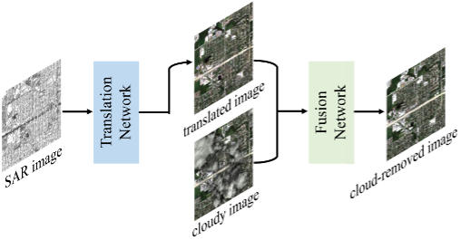
Development of a Semi-Supervised Learning Model for Disaster Object Reconstruction in Partially Cloud-Covered Areas Using Edge Computing on a CanSAT Platform
This research aims to develop a semi-supervised learning model that reconstructs disaster-affected areas obscured by cloud cover. By integrating this model into edge computing devices onboard satellites, the project seeks to enhance real-time disaster detection and prediction capabilities.
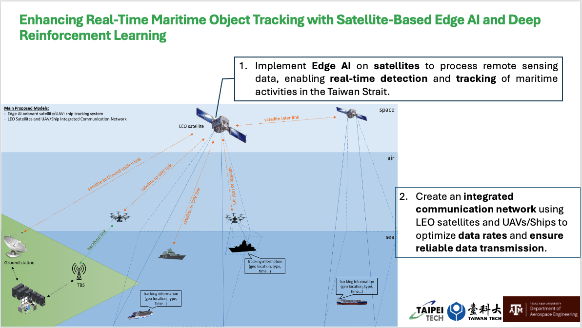
Enhancing Real-Time Maritime Object Tracking with Satellite-Based Edge AI and Deep Reinforcement Learning
1. Implement Edge AI on satellites to process remote sensing data, enabling real-time detection and tracking of maritime activities in the Taiwan Strait. 2. Create an integrated communication network using LEO satellites and UAVs/Ships to optimize data rates and ensure reliable data transmission.